THE DESIDERATA by MAX EHRMANN
THE DESIDERATA a poem written by Max Ehrmann during 1690's. A poem that has touched my heart and soul. And a poem shared to us by our teacher.
I learned that our world is full of danger. Dangerous things that can give us pain, not only physically but also emotionally and psychologically. There is more weight when silencing our thoughts in minds than considering it. We can't control the world, the things that happen to us, our thoughts and specifically our reactions to the things that happen to us. It would be better if we will avoid ourselves to have contact to those that make us vain than collect those thoughts and get angry about it. Change is the only thing permanent in this world. We should change but not for the others to compliment us but ourselves, for us to be proud and be open of what we really feels. For us to be contented for what we have and what we are now and plan for the future without being barrier for others happiness. To sum it all up, it God whom we should entrust ourselves in order to be fulfilled and happy.
I want to know more about how I can be a better person. A better person who is so much contented with what he/she have and to what he/she is really are. And also how can I build better and stable connection with God.
I want to research on how I can be myself, the true me, without hatred and with pure calmness and peace within me.
I appreciate the fact that a poem like this can help students like to be a deeper person with a deeper understanding of what world really has to offer me.
I can apply my insights and learning by being myself, the better me. With poems like this I can have my guide to the path of being a good person/ student. I can also share them with my friends and give them motivations and pieces of advice.
Monday, November 19, 2012
Sunday, November 4, 2012
Blk. 8 Lot 6 Diamond St. ,
Villas de Magdalena,
Poblacion, San Miguel,
Bulacan 3011
November 4, 2012
Dear Mother Earth,
Mother Earth, I want to say thank you for all the things you provided us even if we are not yet born. Thank you for all those things that help us survive. I know that you are not in good condition now. We abused you, we used all those resources you provided. I am very sorry. I know at first we are happy consuming all those but now we are not, we brought you to a critical condition. And now you are giving us the consequences of all the bad things we have done. I know you lost your patience and we are the reason. I know that these consequences you brought might wake us up to all these things and make us realize that we really need to bring you back to the old you. We also know that is very hard and we will try and do our best to bring your back, even little by little in a good condition. Again Mother Earth, we are very sorry and we are also very thankful for the things you had provided. We will do our best for you !
Respectfully yours,
Celine Kate T. Balin
Saturday, October 20, 2012
FUJIWHARA EFFECT

- I learned that FUJIWHARA EFFECT is named after Sakuhei Fujiwhara, is a type of interaction between two nearby cyclonic vortices, causing them to appear to "orbit" each other. The effect is often mentioned in relation to the motion of tropical cyclones, although the final merging of the two storms is uncommon. The effect becomes pronounced in these storms when they approach within about 1,500 km (900 mi) of each other and are at tropical storm strength or stronger.
- I want to know more on why the cyclones approach each other, their centers will begin orbiting cyclonically about a point between the two systems due to their cyclonic wind circulations. The two vortices will be attracted to each other, and eventually spiral into the center point and merge. When the two vortices are of unequal size, the larger vortex will tend to dominate the interaction, and the smaller vortex will orbit around it.
- I want to research on how this Fujiwhara effect happen in our atmosphere. And why it happened A few sets of examples can be found in the busy 1995 Atlantic hurricane season. During the height of the season, Hurricane Humberto and Hurricane Iris took part in a brief Fujiwhara interaction. Iris then began interacting with a third storm, Tropical Storm Karen, which orbited and later merged with the more intense Iris.
- I appreciate the fact that when it happen to us it bring away storm but I am also afraid that it can worsen the case and make the storm stronger and it could bring us a lot of damage.
- All of these information gathered can be the learning and insights that I can share with my family and friends. Also the things that we should do during the occurrence of this phenomena. That could also help us in our community.
PUBLIC STORM SIGNALS


- Public Storm Signal No. 1
- Public Storm Signal No. 2
- Public Storm Signal No. 3
- Public Storm Signal No. 4
- I learned that there are four PUBLIC STORM SIGNALS here in the Philippines. Such as PSS # 1,2,3,3 and that they have a big difference when they are given to your place or province. Public Storm Signal No. 1 may have winds of 30-60 kph may be expected in at least 36 hours or intermittent rains may be expected within 36 hours. Public Signal No. 2 may have winds of greater than 60 kph and up to 100 kph may be expected in at least 24 hours. Public Signal No. 3 may have winds of greater than 100 kph up to 185 kph may be expected in at least 18 hours. And Public Signal No. 4 may have very strong winds of more than 185 kph may be expected in at least 12 hours.
- I want to know more on how does these public storm signals can help us during calamity. And how and why was it given by the authority in our province.
- I would like to research on how a strong tropical cyclone can harbor an area of sinking air at the center of circulation And how it could be measured by the public storm signal. If this area is strong enough, it can develop into a large "eye" and what is the public storm signal in the eye of a tropical cyclone.
- I appreciate the fact that PUBLIC STORM SIGNALS help us a lot during typhoon calamities. It save a lot of people in our community and even our properties.
- All of these information gathered can be the learning and insights that I can share with my family and friends. Also the things that we should do and expect when we are given this storm signal.
Sunday, October 7, 2012
Tropical Cyclone

- I learned that a tropical cyclone is a storm system characterized by a low-pressure center and numerous thunderstorms that produce strong winds and heavy rain. Tropical cyclones strengthen when water evaporated from the ocean is released as the saturated air rises, resulting in condensation of water vapor contained in the moist air.
- I want to know more on why all tropical cyclones are areas of low atmospheric pressure in the Earth's atmosphere. The pressures recorded at the centers of tropical cyclones are among the lowest that occur on Earth's surface at sea level. Tropical cyclones are characterized and driven by the release of large amounts of latent heat of condensation, which occurs when moist air is carried upwards and its water vapor condenses. This heat is distributed vertically around the center of the storm. Thus, at any given altitude (except close to the surface, where water temperature dictates air temperature) the environment inside the cyclone is warmer than its outer surroundings.
- I would like to research on how a strong tropical cyclone can harbor an area of sinking air at the center of circulation. If this area is strong enough, it can develop into a large "eye". Weather in the eye is normally calm and free of clouds, although the sea may be extremely violent. The eye is normally circular in shape, and is typically 30–65 km (19–40 miles) in diameter, though eyes as small as 3 kilometres (1.9 mi) and as large as 370 kilometres (230 mi) have been observed. Intense, mature tropical cyclones can sometimes exhibit an outward curving of the eyewall's top, making it resemble an arena football stadium; this phenomenon is thus sometimes referred to as the stadium effect. It is usually warmest in the center.
- I appreciate the fact that Tropical helps us in the production of rain that contributes a lot on the cropping season of our farmers, that helps in the production of our basic need which is the food. But I know that it can also damage properties and that it could bring harm to us.
- All of these information gathered can be the learning and insights that I can share with my family and friends. Also the things that we should do during the occurrence of this phenomena. That could also help us in our community.
Friday, August 3, 2012
La Niña
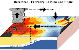
- I learned that La Niña is a coupled ocean-atmosphere phenomenon that is the counterpart of El Niño as part of the broader El Niño-Southern Oscillation climate pattern. During a period of La Niña, the sea surface temperature across the equatorial Eastern Central Pacific Ocean will be lower than normal by 3–5 °C. In the United States, an episode of La Niña is defined as a period of at least 5 months of La Niña conditions. The name La Niña originates from Spanish, meaning "the girl," analogous to El Niño meaning "the boy."

- I want to know more on why La Niña, is sometimes informally called "anti-El Niño", is the opposite of El Niño, where the latter corresponds instead to a higher sea surface temperature by a deviation of at least 0.5 °C, and its effects are often the reverse of those of El Niño. El Niño is famous due to its potentially catastrophic impact on the weather along both the Chilean, Peruvian, New Zealand, and Australian coasts, among others. It has extensive effects on the weather in North America, even affecting the Atlantic Hurricane Season. La Niña is often, though not always, preceded by an El Niño.
- I would like to research on how the results of La Niña are mostly the opposite of those of El Niño; for example, El Niño would cause a dry period in the Midwestern U.S., while La Niña would typically cause a wet period in that area. La Niña often causes drought conditions in the western Pacific; flooding in northern South America; mild wet summers in northern North America, and drought in the southeastern United States.
- I appreciate the fact that La Niña helps us in the production of rain that contributes a lot on the cropping season of our farmers, that helps in the production of our basic need which is the food.
- All of these information gathered can be the learning and insights that I can share with my family and friends. Also the things that we should do during the occurrence of this phenomena.
EL Niño

- I learned that El Niño is defined by prolonged differences in Pacific Ocean Sea surface temperatures when compared with the average value. The accepted definition is a warming or cooling of at least 0.5 °C (0.9 °F) averaged over the east-central tropical Pacific Ocean. Typically, this anomaly happens at irregular intervals of 3–7 years and lasts nine months to two years. The average period length is 5 years. When this warming or cooling occurs for only seven to nine months, it is classified as El Niño/La Niña "conditions"; when it occurs for more than that period, it is classified as El Niño/La Niña "episodes".

- I want to know more about how El Niño events begin when trade winds, part of the Walker circulation, falter for many months. A series of Kelvin waves—relatively warm subsurface waves of water a few centimetres high and hundreds of kilometres wide—cross the Pacific along the equator and create a pool of warm water near South America, where ocean temperatures are normally cold due to upwelling. The weakening of the winds can also create twin cyclones, another sign of a future El Niño.
- I would like to research on how the last several decades the number of El Niño events increased, and the number of La Niña events decreased. The question is whether this is a random fluctuation or a normal instance of variation for that phenomenon or the result of global climate changes toward global warming.
- I appreciate the fact that the first signs of an El Niño are:
- Rise in surface pressure over the Indian Ocean, Indonesia, and Australia
- Fall in air pressure over Tahiti and the rest of the central and eastern Pacific Ocean
- Trade winds in the south Pacific weaken or head east
- Warm air rises near Peru, causing rain in the northern Peruvian deserts
- Warm water spreads from the west Pacific and the Indian Ocean to the east Pacific. It takes the rain with it, causing extensive drought in the western Pacific and rainfall in the normally dry eastern Pacific.
That can give us the clues on how to know if this phenomena will happen that can help us on preparing ourselves.
- With all of these information gathered, I can apply my learning and insights on my everyday life especially when it is summer. That I could apply and determine whether the phenomena occurs the way it should be.
Thursday, August 2, 2012
TAIL-END OF A COLD FRONT

- I learned that a tail-end of a cold front is a front boundary of 2 air masses that are found in the mid-latitudes.

- I want to know more about how a tail-end of a cold front is formed and how does it bring upon rain to the area where it is.
- I would like to research on how a tail-end of a cold front can affect us in our daily lives and how does the tail-end affects the whole cold front that actually is defined as the leading edge of a cooler mass of air, replacing a warmer mass of air, which lies within a fairly sharp surface trough of low pressure.
- I appreciate the fact that it forms in the wake of an extra tropical cyclone, at the leading edge of its cold air advection pattern, which is also known as the cyclone's dry conveyor belt circulation. That also helps the prevention of drought that helps in the cropping season.
- With all of these information gathered I can apply my learning and insights in my everyday life as if I know how most of the occurrence in the climate. Especially the things that happen before or during the wet or rainy season.
MONSOON
- I learned that monsoon is traditionally defined as a seasonal reversing wind accompanied by corresponding changes in precipitation, but is now used to describe seasonal changes in atmospheric circulation and precipitation associated with the asymmetric heating of land and sea. Usually, the term monsoon is used to refer to the rainy phase of a seasonally-changing pattern, although technically there is also a dry phase.
- I want to know more about how monsoon occurs and more about how it can affect us in our lives.
- I would like to research on how the major monsoon systems of the world consist of the West African and Asia-Australian monsoons differ from the inclusion of the North and South American monsoons with incomplete wind reversal has been debated.
- I appreciate the fact that monsoons bring upon rain that ends up the dry seasons which means that it can be the start of the cropping seasons, without the doubt of experiencing drought that would bring upon the wilt of the crops. That provides our necessary need of food.
- I can apply my learning and insights in my life especially during the rainy or wet seasons. With all of these information gathered I have now the confidence of sharing what I have learned with my family, schoolmates and friends that will help us in understanding the occurring of rain after the dry season.
Tuesday, June 26, 2012
Intertropical Convergence Zone
- I learned that known by sailors as the doldrums, is the area encircling the earth near the equator where winds originating in the northern and southern hemispheres come together. It is also known as the Equatorial Convergence Zone or Intertropical Front.

- I want to know more about how it forms and how it develops and how could it be a dangerous typhoon.
- I would like to research on how ITCZ can affect the weather of the wet and dry seasons of the tropics rather than the cold and warm seasons of higher latitudes.
- I appreciate the fact that ITCZ can help in the production of rain that can help us to refrain from drought. The rain it can bring can also help the farmers to grow their plant but only for right amount of rainfall.
- I can apply my learning and insights in my daily life specially during the rainy season. With this knowledge that I have gathered, I can surely understand the things the weather reporter may say about ITCZ and I can share it right to my classmates and friends without any hesitation.
Subscribe to:
Comments (Atom)